* Alper Gölbaş, Instructor, Archeologist, Muğla Sıtkı Koçman University, Ortaca Vocational School, Program of Tourism Guide
Region’s geography in antiquity
Köyceğiz-Ortaca-Dalaman region is characterised by plains, valleys and lakes between mountain ranges stretching from east to west; many civilizations lived here for thousands of years. Rivers formed the valleys as they run over steep shoulders, and plains as they slow down and brought silt and alluvium. Dalaman delta of today is one of them caused by Dalaman river (İndus in antiquity) between Ortaca and Dalaman towns.
The decisive effects of the geographical factors are not limited to this. Dalyan Delta and the İztuzu beach was formed due to the natural change of the course of Dalaman river for a period when Köyceğiz lake was part of the Mediterranean; furthermore, the area between the lake and the bay transformed into a narrow “channel” with two-way currents which is called Dalyan river today (or Calbis in antiquity), playing a decisive role in Kaunos site location. Sultaniye thermal springs are located close to the south end of Köyceğiz lake where the Dalyan river starts. The springs were treated as the Leto Sacred Area in antiquity.
The formation of Dalaman plain directly affected the area where Pisilis ancient site was established (see sect. Pisilis). We know that the Dalaman plain had remained for a long time as a swamp, which was drained and dried up in time during the past 150 to 200 years due to natural as well as human cause. The dried-up swamp area was once farmed to grow cotton; today, it is filled with citrus groves and greenhouses. There are no buildings in the plain older than 150 years but to the slopes and hilltops.
A brief history of the region
The region presents cultural signs of both ancient Carian and Lycian civilizations as it is located at the border of the two. The bordering towns of Caria, starting from Aydın to the north and stretching along the coast up to Dalaman river, and of Lycia between Dalaman and Antalya were lined up in this region. Between Kaunos, which is the last large town of Caria to the south, and Telmessos, which is the large town of Lycia to the north, lie smaller ancient towns such as Pisilis, Lydae, Lissa, Kalynda, Krya, Daedala, Hippokome and Octapolis. There are also smaller settlements, which are known to exist with unidentified locations; Pasanda (Gökbel?), Kymaria (Kışla?) and Euxine (Okçular) are such sites.
The coastal towns in particular, including the ones from Kaunos to Daedala went under the rule of Rhodes between 5th and 1st c. BC. The ruling area, called the Rhodesian “Pereia”, stretched all the way to Knidos at the north of Caria. The Rhodesian influence was reflected in the local culture, particularly on amphoras and coins.
The most important archaeological excavations of the region have been performed at Kaunos, starting at 1966 and in progress without interruption. The findings show that the very first settlements here dated back to as early as 8th c. BC.
The region belonged to Menteşeoğulları before the Ottoman rule, which came in 1451 with Fatih Sultan Mehmet. We know that Kanuni Sultan Süleyman (popularly known as Suleiman the Magnificant), one of the Ottoman rulers during the empire’s rise period, came to Dalyan to proceed his naval expedition to Rhodes in 1522. It was claimed that the Dalyan mosque was built at that time, despite its architectural design suggesting an 18th-19th century building. During the last decades of the empire, the region was left to Hasan Çavuş, a feudal lord.
It is difficult to come across signs of a settlement following the Turkish rule. Despite the permanent residencies at several villages, one needs to remember the local communities were from a nomadic culture. Only a few mosques, holy tombs, fountains and cemeteries are what the nomads left behind at their summer and winter locations.
Ancient sites
Kaunos
Kaunos ancient site is located in Çandır, Köyceğiz, just across from Dalyan. It is the most researched site in the region; regular excavations are performed since 1966 and findings are exhibited in the Fethiye Museum. There is also restoration and cleaning work.
According to archaeological data, the history of the city dates back to the 8th century BC. However, the name of the city was mentioned in sources for the first time in 545 B.C. with resistance to a Persian General Harpagos (Sevin 2001:128). The city joined Attika-Delos Union in 5th c. BC; it was connected to Caria in 377 BC, then to Rhodesian Pereia from early 2nd century until 167 BC. In 129 BC, it was invaded by the Romans, but secured an autonomous status. During Christianity, it became an episcopacy centre connected to Myra, the metropolis at the Lycian border.
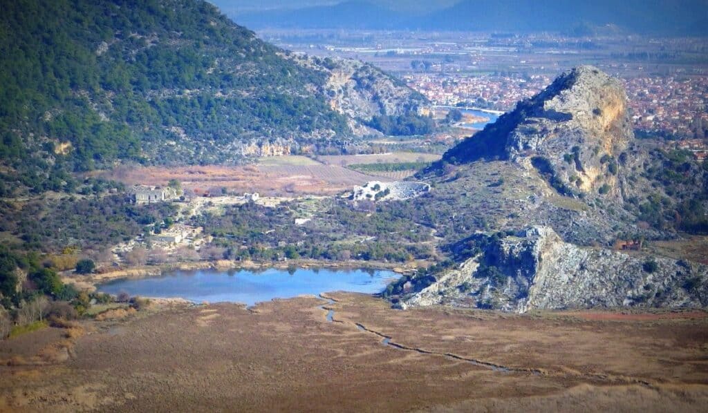
Photo. Kaunos ancient site (Murat Demirci)
Buildings found as a result of excavations give us information about all the civilizations the city went through. A theatre built on the slope of a hill, three churches from early times, a palaestra used for sports activities, a Roman bath, an ancient harbour and a monumental fountain are amongst the current remains (Öğün vd. 2001:53, 67, 79, 118, 127, Diler 2007:76, Işık 1994:1).
One of the most attractive ruins is the rock tombs. 20 of some 150 tombs were built to form a temple in Ionian order. Some of them built as only one-sided, while some others were carved into the rocks in a way that people could walk around.
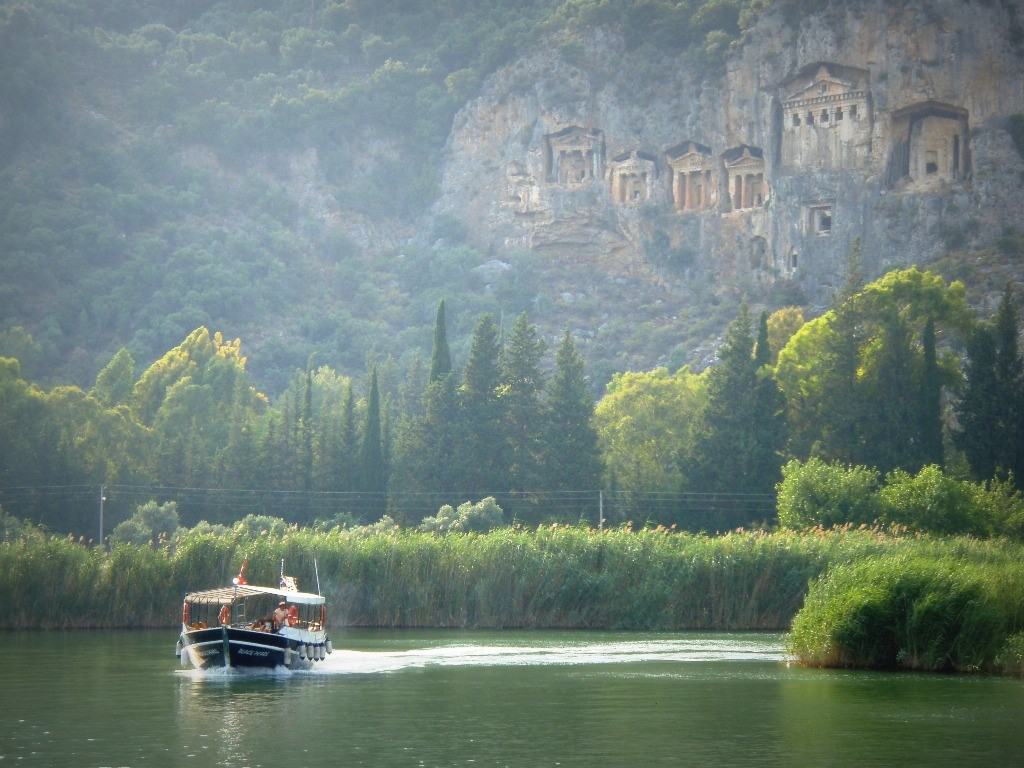
Photo. Kaunos rock tombs (Marulia Soe)
Pisilis
Pisilis ancient site is in Sarıgerme at the Mediterranean coast. Named Prepia in middle ages, the city had ruins from Hellenistic to Byzantium era. Today, there is a hotel built in the 1980s on top of this ancient port town. During the hotel construction, some of the architectural buildings were damaged and the swampy area where the harbour once existed was dried up.
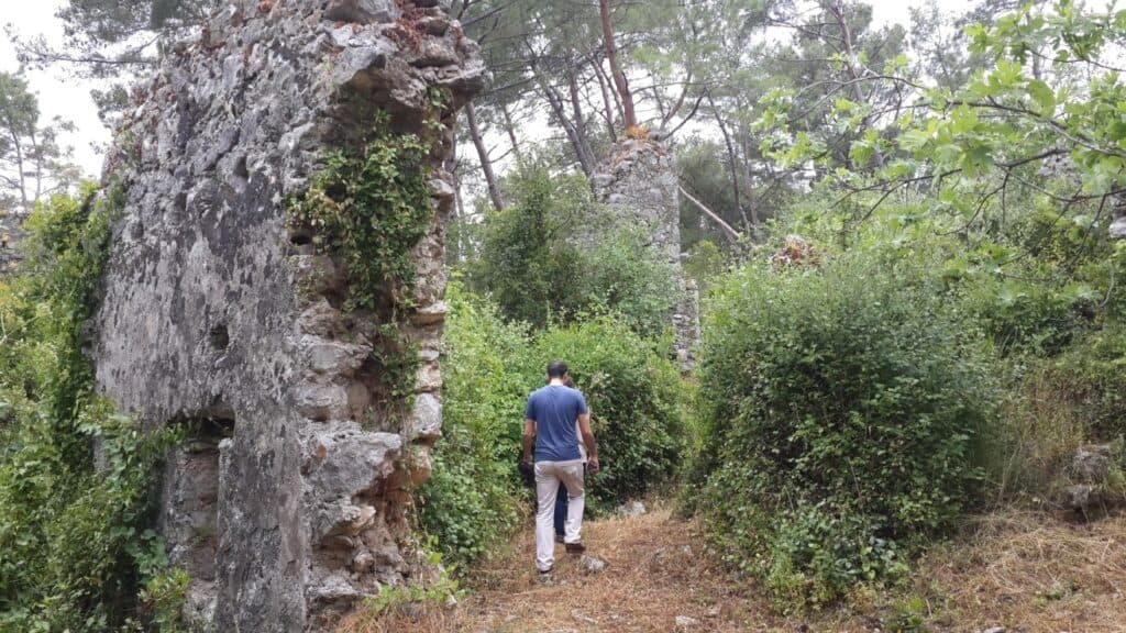
Photo. 11th-12th century building ruins at Pisilis (Gölbaş ve Atak 2016:1216)
Pisilis is currently closed to visitors. Because there are no detailed excavations or field surveys done, stratigraphy hasn’t been done clearly. However, some building remains from the late Roman-early Byzantine era (4th-6th c.) and 11-12 century towards the end of Byzantium era are still erect. Amongst them, some walls, churches planned as the basilica, cisterns and houses can be counted (Gölbaş-Atak 2016:1216).
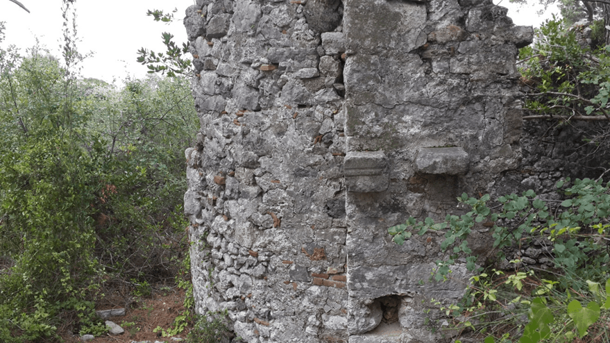
Photo. Outer view of apsis section of basilical chapel in Pisilis (Alper Gölbaş)
Kalynda (Şerefler)
Kalynda was mentioned in antique sources but in only little detail. It is located on the slopes of the hills on the south of Dalaman river, which draws the Carian-Lycian border. According to Strabon, Kalynda was at some 60 stadia (around 9.4 km) inland from the sea, corresponding to what is today Şerefler village. However, because it is not excavated, there is no information available other than the existence of a few structures. The only standing main building is the castle walls on a hilltop overlooking Şerefler and Dalaman. The walls are not very thick, about 220 m long and roughly in the shape of a pentagon.
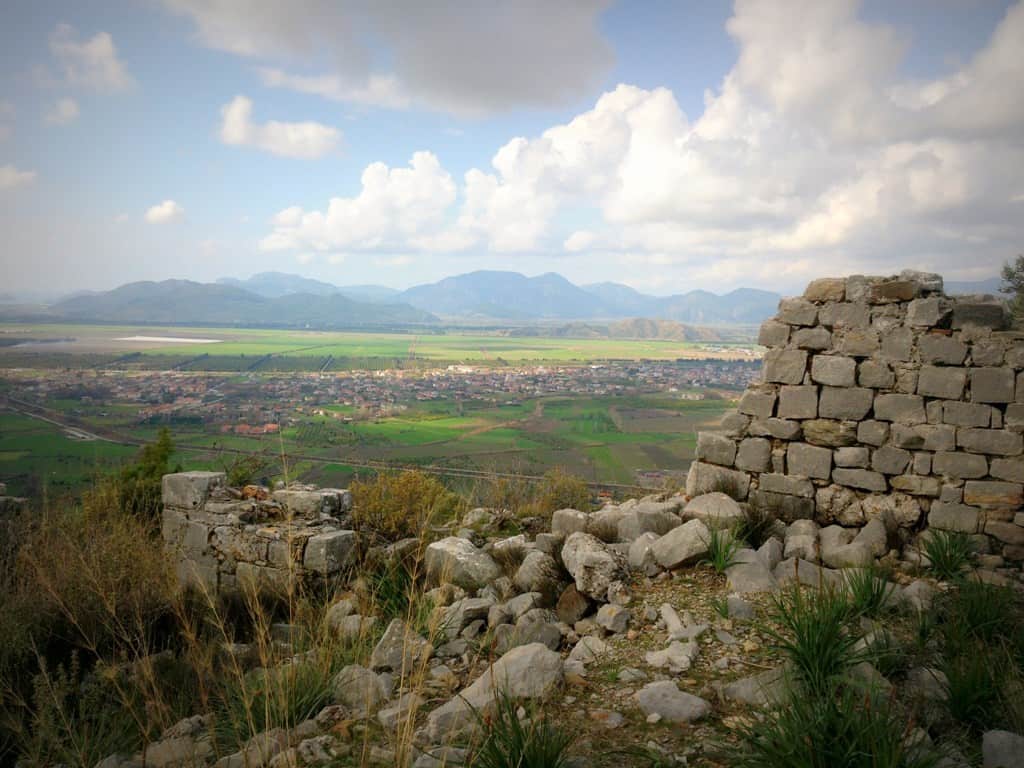
Photo. Dalaman plain as seen from Kalynda castle wall (Murat Demirci)
Lydae (Lydai) and Arymaxa
To the south of Dalaman lies the Kapıdağ peninsula, which separates the Gulf of Fethiye (Glaukos in antiquity) from the Mediterranean in a south-east direction. The ancient sites of Lydae and Arymaxa are located at the southern section of Kapıdağ, where the access is only by boat or on foot due to lack of road connection to the mainland.
The peninsula takes its name from the ruins of a 400m-long wall that was built across the isthmus at its narrowest section. Probably, the wall, which can be seen today, was built to protect the peninsula from the attacks that might come from the mainland (Foss 1994:6). Gökgemile cove is to the west and Hamam cove is to the east of the isthmus.
The information about Arymaxa is limited. It is known, however, that the peoples of Arymaxa and Lydae were in the same community. It could well be the port or outer settlement of Lydae at the northern shores at Yavansu, as suggested by some sources. Monumental tombs are noteworthy, with one having an inscription (Bean:47-48, Umar 1993:117).
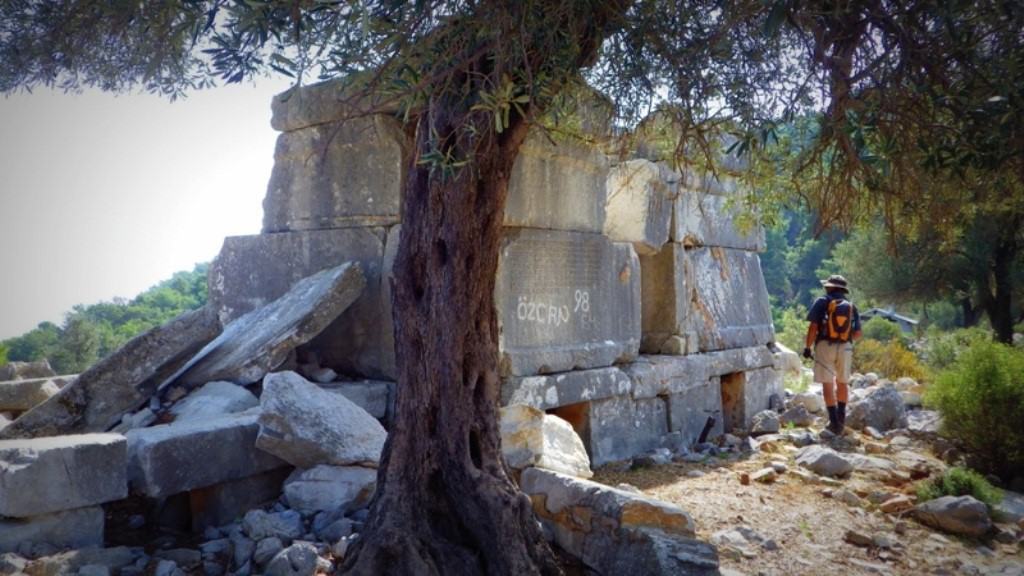
Photo. Monumental tombs at Arymaxa (Murat Demirci)
George Bean, who made research at Lydae found two monumental tombs, an agora and possibly one administrative building with eight seating, and bases of statues. The other ruins are difficult to classify. He also mentioned that he heard about an ancient theatre, however, he couldn’t see it.
According to the ancient authors, Lydae and Arymaxa were established by the people of the same origin and that they produced their own money for a period. The information from Stadiasmus suggests one of the city’s old names was “Kyldai”. The geographer Ptolemaios, however, mentions it as “Khydai” (Bean: 46-47). According to Bilge Umar, Lydai and Lydae mean “the Lidaians” and that the word “Lida” is an Anatolian origin word, with no meaning in Greek (Umar 1993: 518). The high number of examples of civil architecture from the Roman era makes Lydae an important ancient site (Foss 1994:5)
Lissa
Lissa ancient site is located at the north side of Kapıdağ peninsula near Kocagöl. Only Plinus mentioned about it, and not much information is available. The site name is mentioned on the inscriptions located on the partially survived walls which were built in 3rd century BC to the honour of Ptolemaios II. There are no remains other than cistern-type tombs and foundation ruins. Although there is some information about a parliament building and an administrative building in the inscriptions about Lissa, there are no ruins of them (Bean 1998:48-49).
Krya-Kryasos (Taşyaka)
Krya ancient site, which faces Fethiye Gulf (Glaukos Kolpos), is the closest one to Daedala. In written sources, Krya was named as Kryasos and was connected to Delos union (Sevin 2001:130). Lycian type of rock tombs are noteworthy. Besides them, “pigeon nest” type of tombs can be seen. Arkwright, who did research on the region in the late 1880s, mentioned middle age ruins, as well (Arkwright 1895:96).
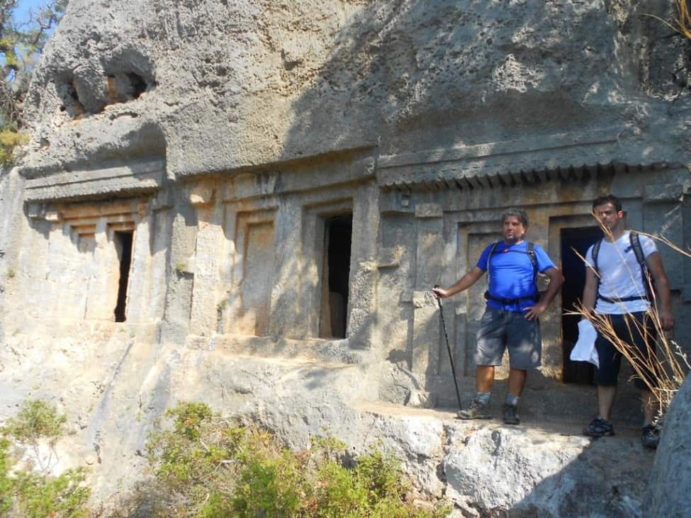
Photo. Rock tombs at Krya (Veli Acar)
Oktapolis
It has been found that Octapolis ancient settlement is built within the borders of today’s Elcik, Sabunlu and Kızılkaya villages. According to Ptolemaios and Herbez, who read about the city from the inscriptions on the tombs, the name of the city was Octapolis, or “eight cities”. An important one of the eight cities is Hippokome, the “city of horses” (Sevin 2001:130).
Rock tombs can be seen on the cliffs to the north of Kayadibi village. Tombs are in Lycian type; but, the rest of the ruins belong to Roman and Byzantine periods. It is very difficult to climb and get closer to the tombs, as they were built on the steep rocks. There are also ruins of walls within Kayadibi; inside these walls, which are considered to be the Octapolis border, are ruins of houses and cellars.
Hippokome
Hippokome means “city of horses”. There are three big rock tombs same as Telmessos on the southwest part of the town. On the right and left of the tombs, stairs that go up to top of the city can be seen. There is a castle surrounding the city and inside the castle, a cistern and ruins, possibly of a cellar. Greek inscriptions also can be seen at this part of the site. Eastern and northern neighbourhoods of Çöğmen village can be seen when overlooked from the castle; to the northwest at Kepezbaşı were the ruins from the Roman and Byzantine era, now almost extinct.
Daedala (Daidala)
The oldest source that gives us information about Daedala, which is located on the mountainous area on the north of Inlice, between Göcek-Fethiye is from Strabon. Strabon mentions that Daeadala was the south border of Rhodos Pereia (Strabon: 173, 191, 193). It is also believed that this ancient city has importance to control land and sea trade because of its location on a place that overlooks Glaukos (Fethiye) gulf.
Rock tombs and also an inner castle and ruins of a wall are noteworthy. Pigeon style tombs can also be seen. Because it can not be accessed easily, it is difficult to do detailed archaeological excavations.
According to Bilge Umar, the name of the city can be rooted to Luwi and separated into three parts as Da-ida-la. “Da”=Goddess or wooden statue, glass, “İda”=forest and “la” can be suffix of “small”, or can mean baby. Therefore it can mean “forest of statues” or Forest of Goddesses or “Forest of Glass”. Bilge Umar tells us a legend from Pausanias.
In ancient Greek, the people who lived in Plataea and Boeotia organized celebrations to memorize this event. There were some rituals very similar to Zeus and Hera rituals. Plataeans named their festival as “Small Daedala Festival (Δαίδαλα μικρά)”, Boeotian called theirs as “Big Daedala Festival (Δαίδαλα μεγάλα)”.
During the Small Daedala Festival, which took place in every four-year Plataeans dropped cooked meat on the way to Boeotia forest in Alalcomene neighbourhood for ravens. After ravens picked up the meat, they placed it on a tree. People of Plataea would cut these trees and make “daedales”, in other words, wooden sculptures.
Big Daedala Festival took place once in every 60 years. Plataeans and Boeotians organized it together. 14 sculptures were made during the festival and given to the cities around. A long convoy would come together and walk through the river up to the altar to sacrifice animals. Daedalas would carry and unload to the altar, bulls were sacrificed for Zeus, camels for Hera, and then they all were burned together (Murray 1875:382).
Legends and festivals show that Daedala means wooden, wood or wooden sculpture. Also, Daidalaos is the first person who tried to fly by making wooden wings like birds’.
Daedala city can not be accessed easily because the ruins are up on a hilly area. But, a big building from Byzantine era located at Inlice beach is believed to be the Daedala port and can be seen easily.
Pasanda (Gökbel)
Information about Pasanda comes from Strabon. Strabon mentions that this city was the neighbour on the other side of Kaunos. There is no clear information about its location and place. It joined Telandros Attika Sea Union and remained on the tax list for 30 years together with Kaunos (Sevin 2001:129, Çörtük 2013:83).
Some suggest that a small village called Gökbel on the way to Iztuzu beach could be Pasanda. The rock tombs and some basic ruins in the village are the evidence of a settlement; however, because there is not any research on this site, it keeps its secrets.